

"Millions across the mid-Atlantic region sweltered Saturday in the aftermath of violent storms that pummeled the eastern U.S. with high winds and downed trees, killing at least 13 people and leaving 3 million without power during a heat wave."

"Power officials said the outages wouldn’t be repaired for several days to a week, likening the damage to a serious hurricane. Emergencies were declared in Maryland, West Virginia, Ohio, the District of Columbia and Virginia, where Gov. Bob McDonell said the state had its largest non-hurricane outage in history, as more storms threatened. 'This is a very dangerous situation,' the governor said."

"The storms raced east Friday and into Saturday from Indiana through Ohio and into West Virginia and the nation's capital, carrying winds gusting as strong as 80 miles per hour."

"Those killed included two cousins in New Jersey, ages 2 and 7, who'd huddled with their families in a tent in Parvin State Park when strong winds felled a pine tree, crushing them. Their relatives all survived relatively unscathed, said Larry Ragonese, a spokesman for New Jersey's Department of Environmental Protection."
"...The storm affected Amtrak service, including shutting down service between Washington and Philadelphia on Saturday morning. But those most inconvenienced were aboard a train that left New York early Friday morning ended up grinding to a halt at 11 p.m. that night in Prince, West Virginia, after trees blocked tracks both in front of and behind it, Amtrak spokesman Steve Kulm said."
Note how corroded the bark is on the trunk of the beech - it should be smooth, like on the younger branch that broke off above.


From Wiki: "To be classified as a hurricane, a tropical cyclone must have maximum sustained winds of at least 74 mph (Category 1). The highest classification in the scale, Category 5, is reserved for storms with winds exceeding 156 mph."
The weakest category of hurricane must have SUSTAINED winds of at least 74 mph - not occasional gusts up to 80 mph max! And that was the brunt of the storm in the mid-Atlantic, not New Jersey, where the two children were killed by a falling tree - or for that matter in North Carolina just last night, where two more adults were killed by a tree on a golf course.

The reason the thunderstorm is being compared to a hurricane isn’t because the winds are that strong – it’s because the tree damage and consequent power outages are comparable to what you would expect from much more ferocious speeds. The same misattribution happened after Hurricane Irene, when so many trees and branches came down in New England - even though the system by then had been downgraded to a tropical storm, and the major result was flooding.
Once again (predictably) the cart is being put before the horse. The power outages, blocked roads and crushed houses, cars and people result from trees falling and branches breaking...and that is happening because they are all dying, from pollution, and NOT because the winds were anything that trees haven't withstood before.

We are having both unprecedented storm damage (and wildfires ) – and can expect far worse – because vegetation is dying off from exposure to ozone. Many people believe air pollution isn’t a problem anymore because the visible component of smog – SOx – has been reduced. However, the background level of invisible tropospheric ozone is inexorably rising, even in rural areas, and it happens to be quite toxic to vegetation, including annual agricultural crops.

There have been many controlled fumigation experiments in the US and Europe that have proved over and again: plants exposed to elevated (over natural) ozone – which is a pollutant derived from reactive nitrogen whether from burning fuel or artificial fertilizer – become significantly damaged. The first effect is that root systems shrink because the plant has to repair injury to leaves or needles. This makes vegetation less tolerant of drought, and more vulnerable to wind. Another major effect is that plants lose their immunity to insects, disease and fungus.
Plants are damaged internally before visible injury appears, but it’s just about ubiquitous now that you can see symptoms on leaves even of plants being watered in pots – tropical plants used to heat. I encourage anyone interested in this issue to go outside and look at leaves and needles. Ozone interferes with photosynthesis so they lose their normal color and eventually turn brown and shrivel up.
Thus, the now-ubiquitous persistent background level of tropospheric ozone is THE ultimate reason that trees all around the world are dying off, even though foresters and scientists are wont to blame whatever localized pest is most apparently attacking them. For some reason, they don’t want to recognize that we have a catastrophic, global decline of vegetation, and to the extent any decline is recognized, it is blamed on warming temperatures.

Meteorologist Dr. Jeff Masters listed some all-time heat records by way of documenting climate change, and of course I accept that trend as ultimately catastrophic. However, what was interesting to me is that all the trees still standing now that are 80 or more years old - and there are plenty of them - have survived through these seemingly unprecedented temperatures that are making us swelter this summer, or within a degree or two, at least once in their lifetime, because the previous records or ties go back to 1930.
If you want to see something really scary, I suggest you visit NASA's site (the U.S. Air Quality Smog Blog http://alg.umbc.edu/usaq/), where the following images were obtained, with excerpts from the notes:109° Columbia, SC (old record 107° on two previous occasions)
109° Cairo, IL (old record 106° on 8/9/1930)
108° Paducah, KY (ties same on 7/17/1942
106° Chattanooga, TN (ties same on 7/28/1952)
105° Raleigh, NC (ties same on 8/21/2007 and 8/18/1988)
105° Greenville, SC (old record 104° 8/10/2007 although 106° was recorded by the Signal Service in July 1887)
104° Charlotte, NC (ties same on 8/9 and 10/2007 and 9/6/1954)
102° Bristol, TN (ties same on 7/28/1952-this site now known as `Tri-State Airport’)
109° Athens, GA. This is just 1° shy of the Georgia state record for June of 110° set at Warrenton in 1959.

6/21
Fires continue taking place over different regions of the nation and also in Canada and Mexico. According to HMS Several areas of smoke could be seen this morning over northwest Mexico, west Texas, southwest Colorado, New Mexico, Arizona, southwest Utah, south Nevada, and southeast California. This smoke is a mix of remnant and new smoke from numerous wildfires burning in the southwest US and in northwest Mexico (bottom left). Also, a large area of aerosol covering the eastern US, and stretching from Kentucky/Tennessee eastward across the Atlantic and northeastward into southern Quebec, is believed to be made up of ozone and other unknown aerosols. At the southeastern edge of the hazy mass of aerosols, a band of what is believed to be smoke from a large fire in southeast North Carolina can be seen extending eastward off the coast. This fire was producing new smoke this morning.

June 25
The most intense heat wave of the summer thus far has commenced over the Plain states, stretching as far north as North Dakota through Southern Texas (bottom left, courtesy Accuweather). Even folks in Denver, CO experienced sizzling temperatures today, rising towards triple digits by late afternoon. Unfortunately, temperatures were not the only indices rising, ozone levels were climbing in tandem with the heat.
June 26
During the daytime hours, you can see the AQI values greatly rise. From 14:00 - 16:00 CDT there is actually a code purple for very unhealthy levels of air pollution. These unsafe levels of air quality are shared between the smoke debris from fires in the area and increased levels of ozone formed in the urban areas. When you have a day like today, that was extremely hot and had very low cloud coverage, there will be a surge of ozone production near factories and major highways. The data and graph below show the hourly surface ozone (ppb) for the Houston area. You can see that it reached almost 150 ppb in some areas (looks like ambient values ~40 ppb).

Okay, ozonists and ozonistas, what is the threshold above which vegetation sustains damage? Ohhhh...40 ppb. Following is a chart from a British company that manufactures equipment for industrial applications to remove ozone from the workplace, and keep in mind that ozone is far more toxic to plants than people:
Concentration ppm
Description of Effects
0.003 - 0.01 Threshold of odour perception by average person in clean air.
0.02 - 0.04 Representative average total oxidant concentrations in major US cities in 1964.
Approximately 95% of oxidants is ozone.
0.1 Recommended exposure limit. Eye, nose and throat irritation often experienced.
0.2 - 0.5 Reduced dark adaptation and alteration of extra-ocular muscle balance occurs after several hours exposure.
0.5 Nausea and headache sometimes occurs. Extended exposure can cause pulmonary oedema and enhance susceptibility to respiratory infections (both bacterial and viral).
1 10 minutes exposure typically reduces desaturation rate of oxyhaemoglobin to 50%.
1 - 2 Chronic exposure (one year for 6 hours per day) at this level has resulted in bronchiolitis and bronchitis in animals. 2 hour exposure can cause headache, chest pain and dryness of respiratory
tract and a reported 30% reduction in timed vital capacity of the lung
1.5 - 2 Exposure for 2 hours typically results in cough, substernal pain and excessive sputum.
5 - 25 Experimentation showed that 3 hour exposure at 12ppm was lethal for rats and 25ppm was lethal for guinea pigs. Humans (welders) exposed to 9ppm developed pulmonary oedema. Their
chest X-rays were normal in 2-3 weeks, but 9 months later they still exhibited fatigue and exertional dyspnoea (Laboured respiration).
50 Thirty minutes exposure may be fatal.

What I want to know is, if the main cause for these uncontrollable wildfires is drought, and dead forests from bark beetles spreading because it doesn't get cold enough in winter, what is all that smoke from fires doing way up north in Canada?


And what about this list of wildfires not just in the exceptionally dry areas from Utah to Texas but in Virginia, North Carolina, California, Minnesota, Oregon, Florida, and Michigan...or this report from NASA: "Russian firefighters have battled uncontrolled fires for months. According to the environmental group Greenpeace, more land in Russia has burned this year than in 2010, a year during which intense wildfires affected western Russia."

In fact, this NASA map of fires around the globe from earlier in June would seem to indicate a very widespread trend not confined to areas in extreme drought:

While this visual of feedback sources includes tropospheric ozone and nitrous oxide, outgassing from melting permafrost.

Wait, speaking of Canada, and the boreal forest, following is a video with lots of cool, refreshing snow from northern Manitoba. But first you must look at this screenshot. What is wrong with these trees?
You'll see the adorable naughty cubs are climbing and pulling on the little trees - but that can't explain why the tall trees have lost needles, high above the ground.

You don't need to watch it unless you have a hankering to guess what sort of funny accent the farmer/narrator has. Or you can trust me that he's telling us about how to grow wheat. The very first step is spreading nitrogen on the fields...see it spray from the truck? Did somebody say excess reactive nitrogen is causing the acidification of the earth?

I tend to prowl tree forums and once, an anonymous somebody asked how to could kill a tree without anyone suspecting. He didn't elaborate as to why, but I assume it was a neighbor's tree that was blocking his view or shading his garden. The advice was simple...over-fertilize it. Works every time...
Meanwhile, the mirage continues. In spite of the smoldering temperatures, First Daughter and husband hosted their annual Pig Roast at Bramblefields Farm on Saturday night.

Aside from bringing flowers and baskets of cherries for the tables, I was given some poster paints and told my job was to make a big sign to encourage nervous guests unused to the country to follow the drive all the way through the woods, about a mile from the main road.

There was a stage for the terrific band, and seating for 150 under two tents situated in the courtyard of the barns.

The horses got lots of attention.

They were fed dozens of carrots.

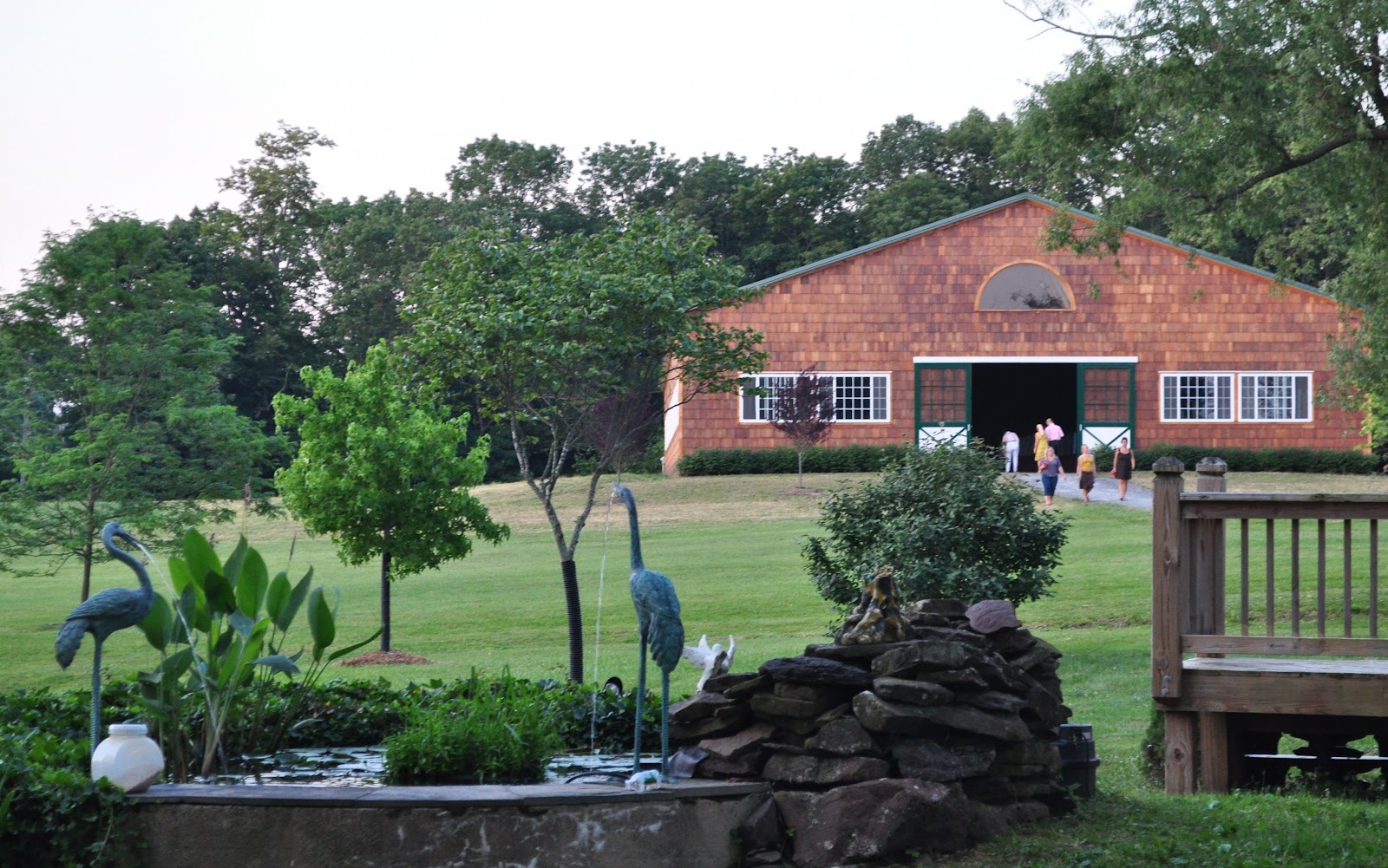
...While the pool had its adherents.

The grounds had been whipped into manicured shape.


...feeding frenzy?

I really enjoyed painting the pig for the barbeque, and I'm thinking, maybe I should go back to art and forget mourning our tragic end. If the ozone doesn't get us first, the weather surely will.

...the survivor bound
In filial obligation for some term
To do obsequious sorrow: but to persever
In obstinate condolement is a course
Of impious stubbornness...


Good show, as always.
ReplyDeleteMicro-wave radiation from cell towers and Wi-Fi Com equipment (including baby monitors) pollute the air and ground (trees and animals) something fierce.
http://www.youtube.com/watch?feature=player_embedded&v=aAnrmJ3un1g
Thanks Plovering. I've been wading through these links because I wonder if there is some synergy between ozone and various types of radiation...but it's all a bit over my head!
ReplyDeletehttp://www.dailycamera.com/ci_15430905
http://www.coronasupplies.co.uk/downloads/Corona%20generated%20Ozone%20In%20house%20Destruction.pdf
http://en.wikipedia.org/wiki/Corona_discharge
She said she was also told that trees weakened by the storm have begun to fall, taking power lines down with them.
ReplyDeletehttp://www.washingtonpost.com/local/sweaty-washington-returns-to-work-mass-outages-persist/2012/07/02/gJQAXLDjHW_story.html
Ha, Michele, they always come up with new creative excuses! One of the best was the Santa Ana winds where they blamed trees growing in concrete, even though most of the ones that fell were in a big, unpaved, wild park! http://witsendnj.blogspot.com/2011/12/root-of-matter.html
ReplyDeleteI don't scare easily, but those mammatus clouds are freaking frightening. Seeing those things overhead would be cause for a major involuntary bowel movement.
ReplyDeleteYeah, I saw something like that about two years ago as a thunderstorm was moving in. It looked like the sky was boiling from underneath, and it was so dark and huge and low, it felt biblical.
ReplyDeleteI've been surprised at the size of the trees that have fallen. Obviously they've survived serious storms before. Gives credence to all ozonisti, for sure.
ReplyDeleteHm, thanks for noticing that Great Blue. You've raised an interesting idea. I wonder if I can find enough statistics to compare the ratio of fallen trees to physical damage to buildings in past storms, to more recent storms. I will have to try to find that information.
ReplyDeleteI'm a noob here, so forgive my confusion, but the ppm and ppb numbers are confusing.
ReplyDeleteIs 40 ppb damaging? Or 40 ppm?
Hi, I've been noticing on some trees here in San Diego that there will be one lone branch, in what looks like an otherwise healthy tree, that has no leaves or needles and is as dry and dead as kindling. I have seen it often enough that it worries me. And then I stumbled on your site and maybe that is what's causing it? I fear for us...
ReplyDelete40 ppb is usually understood to be the threshold above which plants are damaged. (radio interview with John Rielly of MIT here: http://witsendnj.blogspot.com/2012/03/human-volcano.html)
ReplyDeleteLike any other toxin, there is debate about whether it's the dose or the poison, in other worlds, whether it's occasional high peaks that matter most or whether constant low-level exposure causes cumulative damage. This is contentious among doctors about human illness from pollution because it would be far more difficult for industry to comply with lower background regulations. Go to http://witsendnj.blogspot.com/2012/03/something-is-rotten-at-epa.html for their science advisory board discussion on this issue, it's pretty funny!
San Diego - When a tree has branches that are bare, it is usually a sign of decline and an indication there is worse going on internally. I've been to California about 3 times in the past few years (my daughter is in school there). I lived there about 30 years ago and I am completely shocked that people don't realize how brown it has become since then. Of course a lot of forestry types blame sudden oak death on a fungus but ozonists know that trees damaged by air pollution lose their immunity to fungus, disease and insects, just like a person with AIDS.
ReplyDeleteHere are some links with info/pictures about CA:
Sequoia National Park: http://witsendnj.blogspot.com/2012/05/vertigo.html
LA: http://witsendnj.blogspot.com/2011/12/root-of-matter.html
Joshua Tree National Park: http://witsendnj.blogspot.com/2011/02/something-wicked-this-way-comes.html
Esri maps for wildfires as our forests burn. Keep up the good work.
ReplyDeletehttp://tmappsevents.esri.com/Website/wildfire/index.html?bm=top&lrs=news,fir,per,mod,win,prec,youtube,twitter,flickr&ytkw=wildfire&ytr=this_week&twkw=wildfire%20OR%20HighParkFire%20OR%20WaldoCanyonFire&twr=5&flkw=wildfire&flr=4-16-2012,5-16-2012&smd=1&xmin=-18121338.44310785&ymin=3890946.119496931&xmax=-6224067.864579899&ymax=7814305.907317415